 |
| MOUTH OF THE ARNON. |
|
[Table of Contents] [Previous] [Next] |
J. W. McGarvey Lands of the Bible (1881) |
L A N D S O F T H E B I B L E.
PART FIRST.
THE GEOGRAPHY OF PALESTINE.
C H A P T E R I.
GENERAL DESCRIPTION OF THE COUNTRY.
§ I.
THE LAND PROMISED TO ABRAHAM.
THE country promised to Abraham as the inheritance of his offspring is not co-extensive with that which was actually inhabited by the twelve tribes of Israel. The former included the latter, but it extended beyond it both to the north and the south. The promised land was bounded on the west by the Mediterranean Sea, and on the east by the uninhabitable desert of Northern Arabia. A sea of sand on the one side and of water on the other cut it off from approach in either direction.
About midway the southeastern curve of the Mediterranean Sea, a dry stream-bed, now called Wâdy el Arîsh', but known in the Bible as "the river of Egypt" (Gen. xv. 18), reaches the sea-shore by a gradual descent across the desert from the southeast. The mouth of this wâd'y1 marks the southern limit of the coast-line of the land in question, while a line drawn from this point in a southeasterly direction to [19] the head of the Gulf of Ak'abah, and thence eastward to the desert, would mark its southern boundary. The northern boundary would be marked by a line drawn from the river Euphra'tes, at the ancient city of Car'chemish, which stood a few miles above the modern Ba'lis, almost due west to the mouth of the river Oron'tes, near Antioch. The country thus included extends over six and a half degrees of latitude, from 29° 30' to 36° north, and is about 417 miles long in an air-line. Its average width is about 75 miles.
This narrow strip of territory was closely connected at its northern extremity with the seats of ancient empire in Western Asia, while at its southern extremity it was separated only by a narrow strip of desert from Egypt, the dominant power in Africa. Its situation rendered it, throughout all the ages which preceded the invention of great fleets, the highway of commercial intercourse and of military expeditions between the great powers which ruled respectively in Asia and Africa.
The name Syria, which now extends over all this territory, was anciently limited to its most northern portion, with Damascus in the earlier period, and Antioch in the later, as its chief city. The most southern portion, that south of the Dead Sea, was called Edom, or Idume'a; while the district between these two is the one now best known to the world under the name Palestine, the land actually inhabited by the Twelve Tribes. Of the two former we will speak in Part Third; the last commands our attention at present.
While the land given in promise to Abraham was not all occupied by his descendants, it was all at one time in their possession. David extended his conquests over the whole of it, so that both he and Solomon reigned from the Euphrates to the river of Egypt.2 But all beyond the limits of Palestine was held as conquered territory, and it was all lost upon the division of the kingdom after the death of Solomon.
§ II.
THE LAND INHABITED BY ISRAEL.
The boundaries of the land west of the Jordan actually given to the Twelve Tribes are laid down in the thirty-fourth chapter of Numbers; but some parts of the description, especially that of the northern and southern lines, are now obscured by our ignorance of many of the places named in it. It is well ascertained, however, that the actual settlements of Israel did not extend so far, either to the north or the south, [20] as the limits there assigned. We would come near a description of the southern boundary if we should draw a line from the southern extremity of the Dead Sea in a direction a little south of west to Be-er'-sheba, and thence northwest to the Mediterranean shore at Gaza.
The western boundary was the sea-shore, and its northern terminus was the White Promontory,--the cliffs of white limestone which terminate the Plain of Acre on the north. Here the territory of Tyre and Sidon, called by the Greeks Phœnicia, sets in, and this district formed the northern boundary of Israel as far east as Mount Hermon. The town of Dan was usually spoken of as the most northern city of Israel, from the fact that it was so on the route most usually traveled in going north; but the district immediately west of Dan extended a few miles farther north, and was separated from the southern end of Phœnicia by the river Litâ'ny. This river, after rising at Bââal'bec and running southward through the southern part of the plain between the Lebanon and Hermon ranges of mountains, here curves abruptly to the west, cuts through the former range in a chasm from 2000 to 3000 feet deep, and makes its way to the sea. It is a natural and an almost impassable boundary between the two countries. Its Arab name, Kâsîmî'yeh (boundary stream), is probably derived from its ancient use in this particular.
The eastern boundary of the tribes dwelling west of the Jordan was the Dead Sea, the River Jordan, the Lake of Galilee, and the eastern side of the plain through which the upper Jordan flows.
The entire length of the country, "from Dan to Be-er'-sheba," is 139 miles in an air-line, the latter place being in latitude 31° 16', and the former in 33° 16'. Its width at the northern extremity is about 30 miles, and at the southern about 50 miles. The whole area west of the Jordan is about 6000 square miles.
The territory of the tribes which dwelt east of the Jordan was not so long nor so wide. It extended from the river Arnon on the south, a stream which flows westward from the desert and enters the Dead Sea about midway its length, to a line drawn eastward from the northern end of the Lake of Galilee, a distance of about 100 miles; and its average width is not more than 25 miles.
The entire country inhabited by Israel is distributed by its natural features into seven distinct parts,--the Maritime Plain, the Hill Country of Judea, the Plain of Esdra'elon and Adjoining Plains, the Hill Country of Galilee, the Valley of the Jordan, the Dead Sea, and the Country Beyond the Jordan. Of these we will speak separately in the seven following sections of this chapter [21].
§ III.
THE MARITIME PLAIN.
A broad plain extends along the entire sea-coast of Palestine, except where Mount Carmel thrusts its narrow front forward to the water's edge and divides the plain into two unequal parts. That part which lies north of this promontory will receive attention hereafter, the term Maritime Plain being usually limited to the larger portion which lies south of it. It is divided into two parts, the Plain of Sha'ron and the Philis'tine Plain. These are distinguished, not by any natural boundary, nor by any distinct natural features, but merely by the names which they anciently bore. They really constitute but a single plain, unique in all essential features.
The Philis'tine Plain is the more southern portion, and is so called because it was anciently inhabited by the Philis'tines. It extends along the sea-shore about 30 miles, from Gaza to within a few miles of Joppa, and on whatever part of it you stand gaze eastward you see rising before you in the horizon the mountain-wall of the Hill Country of Judea. From the sea-coast back to the feet of these mountains at the northern extremity is about nine miles, and at the southern about 16 miles. It is an undulating plain, and some of its elevations rise as high as 300 feet above the level of the sea. It is crossed from east to west by many streams of water, some of them perennial, but most of them only wet-weather streams. Much of the water which descends from the hills in the winter makes its way toward the sea on the surface of the underlying rock, and rises to the surface in lagoons within a mile or two of the shore. In most parts of the plain inexhaustible supplies of fresh water are found by digging wells of moderate depth. The soil is finely adapted to the growth of small grain, a large quantity of which is produced; yet only a small part of the surface is now cultivated at all, the sparse population seeming to aim at little more than the supply of their own bread. The southeastern part is occupied by Bed'awin Arabs with their flocks and herds, but the remainder is thickly dotted with small brown villages, around each of which there is a small tract of well-cultivated land.
The Plain of Sha'ron extends from a short distance south of Joppa northward to Mount Carmel, and is about 50 miles long. It maintains an average width of about nine miles until it reaches the foot of the hills projecting from the southwestern side of Mount Carmel, when it suddenly contracts to about four miles. Near the promontory which this [22] mountain forms at the sea-shore it is contracted into an acute angle between the mountain and the sea. The plain is traversed by a stream of considerable size, which descends from the hills at the southeastern extremity of Mount Carmel, flows westward along the base of that mountain until it crosses half the width of the plain, then turns a little southward, and empties into the sea two miles north of the ruins of Cæsarea. It is called by the natives the Zerka, or Blue River. It is the largest stream in Palestine, west of the Jordan. Several mills are located on its banks, fish abound in its waters, and it is said that small crocodiles have been seen in it. From this last circumstance it is called by Europeans Crocodile River. Other smaller streams traverse the plain in various directions, but in the latter part of the summer they are usually absorbed by the thirsty soil. As in the Philis'tine Plain, lagoons are formed in many places near the sea-shore by the rise of water, which flows underground from the drainage of the hills; and water is easily found almost everywhere by digging. Good wells exist wherever the people have the energy to dig them, or have had the care to preserve those dug by the ancient inhabitants. Especially is this the case about Joppa, where extensive gardens and orchards are irrigated by water drawn from wells of moderate depth.
What we have said about the fertility of the Philis'tine Plain may be repeated with emphasis concerning the Plain of Sha'ron. One acquainted with the rolling prairies of the Western States of America would imagine himself in the midst of one of these if suddenly put down in the midst of this plain. The only trees visible are the olive-groves immediately about the villages.
The underlying rock along the sea-coast of both sections of the plain is a coarse and soft sandstone. This is disintegrated by the perpetual wash of the waves; they crumble it into sand, and then push the sand out on the shore, where the sun dries it and the wind drives it inland. So long has this process continued that an almost unbroken ridge of yellow sand stretches along the coast, obstructing the outflow of streams, and in some places rising to a height of from 50 to 60 feet above the level of the plain. Much valuable land is thus covered up, and the sea-shore is made to present a desolate appearance. It is estimated that this encroachment of sand upon the soil is advancing inland at the rate of three feet per annum.3 [23]
§ IV.
THE HILL COUNTRY OF JUDEA.
While the mountains which bound the Maritime Plain on the east seem at a distance to rise in a smooth, continuous wall, on near approach they are found, especially along the Philis'tine Plain, to begin with a series of lower ridges. These ridges run north and south, and they rise in some places as high as 1200 feet above the sea-level. Between them and the mountains farther east there is a depression about 500 feet deep, constituting a series of elevated valleys, which separate the range of hills from the range of mountains, and drain the adjacent sides of both. They descend toward the north, the greatest elevation of the country being toward the south, near Hebron, and they finally break through into the plain at a point nearly due west of Jerusalem. These hills are called the Shephe'lah. They do not extend along the Plain of Sha'ron.
East of the Plain of Sha'ron, and of the elevated valleys just mentioned, rises the central mountain ridge of the country, and it extends in width to the Dead Sea and the valley of the Jordan. That part of it which lies south of Jerusalem is called in Scripture the Hill Country of Judah, because it was occupied by the tribe of Judah; and that north of the city Mount Ephraim, because the powerful tribe of Ephraim occupied the chief part of it. Its water-shed lies nearer the eastern than the western side, and runs in a crooked line from Hebron northward by Bethlehem, Jerusalem, Bethel, and She'chem to the vicinity of Mount Gil'boa, a distance of 65 miles. Its average elevation is about 1500 feet, but its highest point, which is 3 miles north of Hebron, is 3300 feet high, while that of Bethlehem is 2900 feet, that of Jerusalem is 2600, and that of Mount Ebal, overlooking She'chem, is 3076.4
From both sides of this central ridge are projected long and crooked outstretching spurs, which sometimes make a gradual descent toward the lowlands, and sometimes rise in tall peaks or ridges which break down suddenly into the plains. Between these spurs are deep, narrow gorges, called wad'ies, which drain the mountains, and along whose rocky beds there are many copious springs. These wadies, beginning at the water-shed as slight depressions on the right and left of the highway, rapidly grow deeper and narrower, until they often attain [24] a depth of from 1000 to 1500 feet before they reach the level of the plains to which they descend. Those on the eastern side are more abrupt and rugged than those on the west, both because they make their descent within a shorter distance, and because their descent is greater,--the valley of the Jordan, to which they descend, lying at a much lower level than that of the Maritime Plain. They are washed by mountain torrents during the heavy rains of winter, and by babbling brooks in the spring; but most of them become entirely dry as the summer advances. The roads running east and west across the country follow their stony beds or pass along narrow benches cut in their steep sides, while the principal route of travel north and south follows the line of the water-shed.
That part of the eastern slope which lies west of the Dead Sea is the most rugged and barren portion of the whole country. The barren region begins a few miles east of the water-shed, and extends along the entire length of the Dead Sea. It is about 45 miles long, and from 8 to 10 miles wide. It is very correctly and graphically described by Lieutenant Conder in the following words:
"The character of the rock is different from the stratified limestone of the mountains above. It is a white, soft chalk, which is worn by the winter rains into long, knife-edged ridges, separated by narrow ravines with stony beds. The sea-breeze never visits this ghastly desert, which is fitly called in Scripture Jesh'imon, or Solitude. Thus, though in spring the naked slopes are thinly covered with grass and flowers, it presents throughout nearly the whole year a long succession of glaring ridges, with fantastic knobs and peaks, and sharp, rugged spurs, absolutely treeless and waterless."5
Nearly all travelers who visit this desolate region suffer much from the intense heat, the glare from the white hill-sides being as fierce as that from the burning sun itself. The writer just quoted says, "There are probably few places in Asia where the sun beats down with as fierce and irresistible a power as in the Desert of Judah."6 The author's experience in traversing it was exceptional. We occupied three days--May 13-15--in an excursion from Hebron to the Dead Sea, and we enjoyed a cool north wind from noon on the 13th to sunset on the 15th. The 15th was indeed a chilly day. We rode all day in our overcoats, and the temperature the following night at Hebron was as low as 55° Fahrenheit.
Next in ruggedness to the chalk hills west of the Dead Sea is the [25] section immediately north of it, lying east of a line between Jerusalem and Bethel. Along the road between these two towns, which are 12 miles apart, the surface consists very largely of naked rocks, and the hills to the eastward are very rugged, growing more so as we approach their termination in the volcanic and barren mountains which overhang the Jordan Valley near Jericho. This region was occupied by the tribe of Benjamin.
North of Bethel, on both sides of the water-shed, the hills are more rounded, the valleys wider, and the general aspect of the country is more pleasing. The same is true of the western slope, opposite the two sections first described above.
The Hill Country terminates at the north, with Mount Gil'boa on the east, and Mount Carmel on the west. The former is a lofty ridge, extending from the line of the water-shed in a southeasterly direction to the Jordan Valley; and the latter, commencing a few miles west of the same line, extends 12 miles in a northwesterly direction to the Mediterranean Sea.
§ V.
THE PLAIN OF ESDRA'ELON AND ADJOINING PLAINS.
The Hill Country, at its northern extremity, breaks down into three connected plains, the central and largest of which is the Plain of Esdra'elon. It is triangular in form, its longest side being towards the southwest, and extending from Jenîn', in the southeast angle, in a direction a little north of west to Mount Carmel, and along its northern base about one mile. This side is 25 miles long. The eastern side starts also from Jenîn', and runs north past the western foot of Mount Gil'boa to Mount Tabor. It is 14 miles long. The northern side, starting from Mount Tabor and running a little south of west, skirts the hills of Galilee and terminates at Mount Carmel, where it forms an angle with the southwestern side. It is about 16 miles long. No one of these sides is entirely straight, for the plain, on every side, forms numerous bays running into the mountains. Its elevation is from 200 to 250 feet above the level of the sea, and its slope is toward the Mediterranean. It is drained by the river Ki'shon, which flows through the middle of it, collecting the waters of many springs which break forth near the hills on every side. This river passes out through a gap about half a mile wide between Mount Carmel and the Galilean hills at the northwest angle of the plain. Thence it runs nearly parallel with the northern base of Mount Carmel until it empties into the Bay of A'cre. That part of it which is below the gap [26] is perennial, with a sluggish current and a bed of mud. The part above the gap frequently goes dry in summer. It was entirely dry when seen by the author, in June, 1879, after a very dry winter.
In this plain occurred two very important events in the history of ancient Israel. It was here, on the banks of the Ki'shon, that Deb'orah and Ba'rak defeated the army of Ja'bin under Sis'era, and the retreat of the routed army was along the course of the river, though their commander fled in another direction.7 It was here also, near Megiddo, on the southern edge of the plain, that Josiah, king of Judah, encountered the army of Pharaoh Ne'cho, king of Egypt, who was on a march to the Euphrates, and was defeated and slain,--the first and only king of Judah who fell in battle.8
In the Old Testament this plain is called the Valley of Jez'reel, from the city of Jez'reel which stood at its eastern side, on a spur of Mount Gil'boa,9 and Esdra'elon is but a Greek corruption of that name. It is called by the present inhabitants, who seem to be totally ignorant of its ancient history, Merj Ib'n Amîr', the Meadow of the Son of Ameer'.
There are no large towns in the plain except Jenîn', and no villages except a few very small ones on its eastern side. If any towns were ever built in the interior of the plain, they were constructed of perishable material, and all traces of them have disappeared. The soil is of volcanic origin, and exceedingly rich; but on account of annual incursions of Bed'awin from beyond the Jordan, who resorted to it for grazing purposes, and often robbed the surrounding villagers, it was not much cultivated until a few years ago. Now it annually produces large quantities of grain, and Conder states that in 1872 nine-tenths of it was in cultivation.10
From the eastern side of the Plain of Esdra'elon there opens a gap about four miles wide between Mount Gil'boa and a mountain north of it, called Jebel Dû'hy. This gap opens into a plain, which widens as it extends eastward until it reaches Beisan', where it breaks down by a precipitous descent of about 400 feet into the valley of the Jordan. To this plain the name Valley of Jez'reel is now confined. It is about 12 miles long, and it occupies the space between the two mountains just named, which recede from each other as they extend eastward, Jebel Dû'hy inclining northward, and Mount Gil'boa southward. The plain is not less than 10 miles wide where it breaks down into the Jordan Valley. [27]
A number of fine springs issuing from the northern base of Mount Gil'boa and spreading over this plain, render the eastern portion of it green and marshy in summer when all around it is parched and dry. The largest of these, situated a mile and a half east of Jez'reel, is called Ain Jalûd', and it is the source of a stream which, when swelled by the streams from other springs, becomes the river Jalûd', the largest of the western tributaries of the Jordan. Many mills along the plain are propelled by the water of these different streams. The dryer parts of the plain are well cultivated, and the marshy portions afford summer pasturage. It is claimed by Bed'awin from beyond the Jordan, who resort to its green pastures and luxurious canebrakes when the advancing summer has dried up the vegetation of the plains in their own country. No villages now exist on the plain, except the miserable and insignificant hamlets of Jez'reel and Shu'nem at its western end, and the equally wretched village of Beisan' at the eastern end.
It was in the upper end of this valley that the host of the Midianites, the Am'alekites, and the Children of the East were spread abroad when Gideon came down upon them from his camp on Mount Gil'boa and defeated them with his three hundred men.11 It was at Shu'nem, near the head of the valley, that the Philis'tine army was encamped before the fatal battle in which King Saul was defeated and slain. Saul's army was encamped at Jez'reel, and his retreat was over the slopes of Mount Gil'boa. Somewhere on that mountain the dead bodies of the king and his sons were found by the Philis'tines, who gibbeted them on the walls of Beth-she'an (Beisan'), at the eastern end of the same valley.12
The Galilean hills, which bound the northern side of the Plain of Esdra'elon, make a gradual curve on the western side of the plain and approach Mount Carmel at a right angle. But they are separated from it by the narrow pass already mentioned, through which the Ki'shon flows. This pass connects the plain with the Plain of A'cre, which lies at a lower level, and stretches away to the Mediterranean. This latter plain is therefore a part of the same series of plains to which those of Esdra'elon and Jez'reel belong, and which extends from the Jordan Valley to the Mediterranean Sea. Its width, from the mountains to the sea, is from 8 to 10 miles, and its length from north to south is about 16 miles. Mount Carmel forms its southern boundary, and its northern is the mountain-wall of Phœnicia, which terminates at the sea-coast in a lofty bluff of white limestone, called the White Promontory. [28]
This plain lies but a few feet above the level of the sea. In many places it is marshy, and the marshes are crossed from east to west by paved roads, the flat stones of which are laid on an elevated bed. It possesses a rich soil, and its surface is dotted with a multitude of villages, whose inhabitants cultivate a large area in grain. It is indented on the southwest by the Bay of A'cre, whose shore has the curve of a bent bow. The southern side of its mouth is near the foot of Mount Carmel, and the town of Haifa stands there, on a narrow slope between the mountain and the bay. On the opposite side of the mouth, and in the angle between the sea and the northern side of the bay, stands the town of A'cre, from which the bay and the plain both derive their names. It was known in the New Testament period as Ptolemais (Acts xxi. 7), and the plain is called by Josephus "the territory belonging to Ptolemais." It has had an eventful history, and it is now the only well-fortified place in Palestine; but Haifa, being the landing-place of the steamships, is fast gaining on it in population, and already excels it in commercial importance.
§ VI.
THE HILLS OF GALILEE.
The section of plains last described, with the exception of the Plain of A'cre, belonged to Galilee, and were the southern portion of that district. According to the description given by Josephus, the authority on this question, Galilee was bounded on the south by Samaria, and the latter district began with "Gin'ea,"13 which is the modern Jenîn', on the southern extremity of the Plain of Esdra'elon. That portion of Galilee which lies north of these plains is a hill country. The ascent from the Plain of Esdra'elon to the general level of the southern end of the hill country is about 1000 feet. The ascent continues toward the north, approaching in elevation, as in distance, the southern end of the Lebanon range of mountains, until it reaches, in the highest points near the Litâ'ny River, an elevation of more than 4000 feet. The deep gorge of the river just mentioned14 constitutes its northern boundary, while on the west it is bounded chiefly by the Plain of Acre, and on the east by the Lake of Galilee and the upper and lower Jordan Valley.
The account of Galilee given by Josephus represents it as it was when frequented by Jesus and made the chief field of his earthly [29] labors. He says that its soil was "uniformly rich and fruitful;" that it was "full of plantations of trees of all sorts;" that it was all cultivated, no part lying idle; and that it contained two hundred and forty cities and villages.15 The same may be said of its soil at the present time, and its hills are even yet more wooded than those of the southern hill country. They are not so steep nor so bare of soil, and the valleys between them are broader. Many villages, and some towns of considerable size, still exist there. Of the latter, Nazareth is the largest, Tiberias the next, and Safed the third in size. But great changes in the relative importance of places have taken place. For example, Seph'oris, now called Sefurï'eh, about three miles north of Nazareth, was then, according to Josephus, "the greatest city of all Galilee,"16 while Nazareth was so insignificant that it is not once mentioned except in connection with Jesus. Now Sefurï'eh is an insignificant village and Nazareth is a large town. Only a small portion of the country is now in cultivation, but the soil yields a good return for the labor bestowed on it.
§ VII.
THE VALLEY OF THE JORDAN.
That portion of Palestine thus far described is bounded on the east, along its entire length, by the valley of the Jordan. If you stand on the slightly elevated site of the ancient city of Dan and look to the south, you see before you the most northern section of this valley. It stretches before you, apparently a dead level, about 20 miles, and it is about five miles wide. A mountain wall rises from it on either side to a height of from 1500 to 2000 feet, while the horizon at the farther end of it is bounded by low hills jutting out from the mountains on either side. It is called the Plain of Hûleh. The site of Dan, on which you are standing, is at the northern extremity of the plain, and if you turn and look northward, you see that from the north end of the plain arise the spurs of Mount Hermon, terminating, to the northeast, in the snow-covered summit of that lofty mountain.
The site of Dan is a mound about 30 feet high, and under the western side of it there issues from the ground one of the largest springs in the world. It sends forth a stream about 20 feet wide, and from 20 to 30 inches deep, which flows southward along the middle of the [30] plain, and is hidden in the distance by a jungle of weeds, cane, poplars, and other vegetation, which grow with a tropical luxuriance. This spring is the central and principal source of the river Jordan, and the stream which flows from it is called the Leddân'.
Two and a half miles east of Dan are the ruins of Ban'ias (Cæsarea Philippi), under whose northern wall issues another spring about half as copious as the one at Dan. The stream which flows from it, starting from an elevation nearly 1000 feet above the lowest part of the plain, rushes rapidly away toward the southwest, and enters the Leddân' about six miles from the source of the latter. This spring is the eastern source of the Jordan.
About one mile and a half west of Dan, the road running in that direction crosses a bridge built of black rock, which spans a rapid mountain stream lying deep within its bed of the same rock. This stream is the Hasbâ'ny. It is about equal in size to the stream which flows from Cæsarea Philippi, and it issues from a third spring near the town of Hasbeiah, under the western side of Mount Hermon. This spring is the western and most distant source of the Jordan, and the stream empties into the Leddân' a short distance below the mouth of the one from Cæsarea Philippi. All three of these noted springs maintain a copious flow throughout the dry season, being led by the melting of the snows on Mount Hermon. The snow-water finds its way between the rocks down into the foundations of the mountain, whence it is forced up, icy cold, into these and many smaller springs.
After the junction of these three streams, the Jordan flows southward a few miles farther, and then expands into Lake Hûleh, called in the Bible the Waters of Merom. This lake is triangular in shape, being about 3 miles wide at its northern end, and coming to a point at its southern end,--length, 4 miles. Its northern end is 12 miles from the central source at Dan. Its average depth is only about 11 feet (Baedeker), and it lies on a level with the Mediterranean Sea (Conder, ii. 35). The plain, in the immediate vicinity of the lake, is too wet for cultivation, so wet that the lake-shore can be reached only from the east and the southwest; but the chief part of it is tillable, and all is exceedingly rich. It contains no villages, but is cultivated by a tribe of Bed'awin Arabs, who pitch their tents near their grain-fields, and pasture their stock on the luxuriant natural vegetation.
From the southern end of the lake the Jordan starts again on its course. At first it glides tranquilly between sloping banks, but after passing under an ancient stone bridge one mile and a half from the lake it begins to descend very rapidly. It cuts through the hills which [31] bound the southern end of the plain, in a narrow gorge between perpendicular walls of black rock, and rushes down a continuous succession of rapids and cascades until it nears the Lake of Galilee, when it reaches a level and runs slowly into the lake. The entire distance from Lake Hûleh to the Lake of Galilee is 10½ miles, and the difference in elevation between the two is 682 feet. The Jordan makes nearly all of this descent in 8 miles, a fall of 85 feet to the mile.
The Lake of Galilee, like Lake Hûleh, is but an expansion of the river Jordan. It is 6 miles wide at the widest part, and 12½ miles long. The curve of the northern shore continues to widen toward the south, until it reaches a distance of 4 miles, when the shores begin to contract toward a narrow point at the southern end. The southern point lies eastward of a line drawn along the middle. The form of the lake is not unlike that of a longitudinal section of a pear, with the stem-end toward the south, and turned a little to one side. It is bounded on the east and west by a continuation of the same mountains which bound the plain of Hûleh above, and they maintain about the same relative height; but the level of the lake, according to Conder, who carried the levels from the Bay of Acre, is 682 feet below that of the Mediterranean (ii. 177). Its water is clear, and deepens gradually from the shore on every side. Its greatest depth is 165 feet (Lynch, p. 165). It abounds in fish, as it did of old, but the fleet of boats which once dotted its surface with their white sails is now reduced to three, and even these find only partial employment in supplying the market of Tiberias, the only town now left on shores which once were packed with a dense and busy population.
The lake is often visited, as it has ever been, by sudden storms, which literally come down upon it from the surrounding mountain-tops (Luke viii. 23), and in a few moments lash its waters into fury.17
This lake, during the long period of its history, has passed under a variety of names. When first mentioned in the Bible it is called the [32] Sea if Chinnereth, probably from a city of that name which stood on its shore.18 In the New Testament it is sometimes called the Lake of Gennesaret, from the small plain on its western shore called the Land of Gennesaret; sometimes the Sea of Galilee, from the country west of it; and twice the Sea of Tiberias, from the town of Tiberias on its western shore. This last title, found only in the latest of the New Testament narratives, still clings to it in the Arabic form of Bahr Tabari'yeh. Of the plain and hills, the springs and streams, the towns and villages, which are or have been about its shores, we will speak under the proper headings in the topographical part of this work, adding here only the remark, that its shores possess nothing to especially interest the traveler apart from their historic associations. It could not have been his taste for either the grand or the beautiful which led Jesus to make it a place of so frequent resort.
From a pointed bay in the southeastern19 extremity of the Lake of Galilee the Jordan makes its exit, running first a little north of west for about a mile (compare Lynch, 172), when it makes a short curve to the south, and fairly starts on its serpentine course toward the Dead Sea. The whole distance from the lake to the sea is only 65 miles, but so crooked is the channel of the river that in traversing this distance it runs 200 miles (Lynch, 265). It runs, in its countless meanderings, to every point of the compass, but it makes no long bends; and it falls during this part of its course 610 feet, the difference between 682 feet, the depression of the Lake of Galilee below the Mediterranean, and 1292 feet, that of the Dead Sea.20 The rate of its descent is by no means uniform. According to Conder, this part of the river may be divided in this respect into three sections. From the lake to the Dam'ieh ford, 42 miles, it falls 460 feet,--an average of nearly 11 feet to the mile; but in a part of this section it falls forty feet to the mile. The second section is one of 13 miles, with an average fall of only 4½ feet to the mile; and the third is one of 10 miles, with a fall of 9 feet to the mile. With such a fall the river would be a torrent but for its many short bends, and for the many places in which the descent is by a succession of rapids, alternating with pools and level stretches in which the current is slow.
From about 8 miles south of the lake the Jordan runs in a valley within a valley, the inner valley varying from a quarter of a mile to a [33] mile in width, and lying from 100 to 200 feet below the level of the upper and wider valley. Along this narrow depression the river winds about from side to side like a coiling serpent, and its immediate banks are everywhere thickly set with small trees and undergrowth. From the Lake of Galilee to the beginning of this depression the bed and banks of the river are composed chiefly of basalt, but throughout the remainder of its course it flows over a bed of sandy clay, except at a few points where the naked rock or beds of gravel are exposed. At these places are fixed the fords and ferries. Of the latter there are at present only two at which ferry-boats are kept,--the Dam'ieh ferry, above mentioned, and one opposite Jericho. Fords are much more numerous. Conder obtained the names of more than forty, and among them was one called Abâr'ah, which he identifies with the Beth-ab'arah of John i. 28. Of these we will speak more particularly in Part Second.
The Jordan has only four perennial tributaries. Of these, two enter it from the west and two from the east. Of the former two, the more northern is the Jalûd', which has its source in the valley of Jez'reel, and flows thence through the ruins of Beisan' (Bethshean), and thence to the Jordan. The more southern is the Far'rah, whose source is on the northern slope of Mount Ebal, whose current supplies the "much water" of "Enon near to Salim," and which enters the Jordan a short distance south of the Dam'ieh ferry. The latter is the smaller of the two. Of the other two, the more northern, and by far the largest of the four, is the Yar'mûk, whose mouth is about six miles south of the Lake of Galilee. It is nearly as large as the Jordan where they unite. The other is Wady Zerka (the river Jabbok), which empties into the Jordan a half-mile above the Dam'ieh ferry. Besides these perennial streams, there are several winter streams on the west, and a still larger number on the east, which contribute to the swelling of the river during the winter and spring, but whose diminished waters in the dry season are absorbed in the thirsty plain.
The volume of water which flows in the Jordan may be estimated by its size at the Dam'ieh ferry, below which it is not materially increased by tributaries. Here the author found it by accurate measurement, in April, 1879, 130 feet wide from water's edge to water's edge, 8 feet deep in the channel near the eastern bank, with a gradual slope to that point from the western, and flowing in the channel at the rate of about 5 miles to the hour. On the 27th of February, 1871, Captain Warren found it at the same place "quite sixty yards in width, and running like a mill-race," while many branches from the overflow of the river [34] were meandering through the inner valley.21 When seen by President Bartlett, in March, 1874, not far above its mouth, that writer describes it as follows:
"The river was very high. We were fortunate enough to see it in the state in which it is described in Joshua, 'overflowing all its banks'--that is, the whole line of its banks. The turbid stream rushed along like a mill-race; and though it had fallen from its greatest height, the proper banks of the stream were invisible, and indicated only by lines of oleanders and other shrubs and trees."22
Doctor Robinson, though he made no measurements himself, quotes the statements of several other writers as follows:
"At the ford, near Beisan', on the 12th of March, Irby and Mangles found the breadth to be one hundred and forty feet by measure; the stream was swift, and reached above the bellies of the horses. When Burckhardt passed there in July, it was about three feet deep. On the return of the former travelers twelve days later (March 25), they found the river at a lower ford extremely rapid, and were obliged to swim their horses. On the 29th of January in the same year, as Mr. Bankes crossed at or near the same lower ford, the stream is described as flowing rapidly over a bed of pebbles, but as easily fordable for the horses."23
The upper valley of the Jordan varies greatly in width, and is divisible, with reference to width, into six sections. The first, extending below the lake 13 miles, is about 4½ miles wide; the second, extending 12 miles farther, is 8 miles wide; the third contracts to 2 or 3 miles on the east, with a high table-land, not a valley, on the west,--it extends 12 miles; the fourth, 10 miles long, is 8 miles wide,--three on the west of the river, and five on the east; the fifth, about the same length, is more than 10 miles wide; while the sixth and last, extending from a short distance above Jericho to the Dead Sea, is 8 miles long and 14 wide, the Jordan running through the middle. If we add to these the basin filled by the Lake of Galilee, 12½ miles long, and the plain of Hûleh, 26½ miles long, we have, in eight sections, the entire valley of the Jordan, and find it 104 miles in length, with an average width of about 7 miles. But the singular depression of which this valley forms a part extends much farther toward the south. It includes the basin of the Dead Sea, 45 miles long, and also the sandy valley running south from this to the head of the Gulf of Ak'abah, 100 miles farther. Throughout this entire distance of 250 miles, from Dan [35] to the Gulf of Ak'abah, there is a great rent in the earth's crust, the walls standing from 4 to 14 miles apart, and the sunken space between occupied by the Jordan Valley, the Dead Sea, and the valley south of the Dead Sea, called the Ar'abah. That portion of it which extends from the Lake of Galilee to the Dead Sea is called by the Arabs El-Ghor, the Depression, showing that its low level has not escaped the notice of these uneducated people. In the Bible it is called "the plain," or "the plain of the wilderness."24
Of the ruins to be found in the valley, its streams of water, and its historical localities, we will speak under the proper special headings.
§ VIII.
THE DEAD SEA.
Although the basin occupied by the Dead Sea is but a continuation of the Jordan Valley, being but a deeper depression of that valley filled with water, it is proper on account of its peculiarities that it be considered in a separate section.
As we have stated above, its entire length is 45 miles, and its average width 10. Its eastern and western shores throughout the chief part of its length are nearly parallel, so that its width is quite uniform. Its surface, according to Lieutenant Lynch's estimate, based upon a series of levels carried from its western shore to the Mediterranean at Joppa, is 1312 feet below the level of the sea; but, according to Lieutenant Conder, it is 1292 feet. Its greatest depth, according to Lynch, is 1308 feet, and its bottom inclines downward from the western toward the eastern shore. It is the lowest lying body of water in the world.
Toward its southern end a low peninsula, called the Lisân' (the tongue), juts out from the eastern shore, and extends to within two miles of the western. The length of this peninsula, from its northern to its southern cape, is about 10 miles. These capes were named by Lynch,--the former Cape Costigan and the latter Cape Molineux, in honor of previous explorers. The water in the strait between it and the western shore, though 642 feet deep at the northern extremity, is only 18 feet deep at the southern. The surface of the peninsula at its northern cape is 260 feet above the level of the water, but at its neck it is nearly on a level with the water. The neck of the peninsula is not more than half as far across, north and south, as its extreme [36] western shore. It has a good soil, and it would be very productive if supplied with water.
That portion of the sea which lies south of this peninsula is almost circular in shape, and is a mere lagoon, varying in depth from 3 to 12 feet. It was conjectured by Dr. Robinson, in 1838, that this lagoon was once the Plain of Sodom, and that when that city and the plain on which it stood, together with four neighboring towns, were burned, the bitumen with which the soil was impregnated was consumed to such a depth as to leave a depression of the surface, into which the sea flowed and formed the lagoon. He also conjectured that by means of simultaneous volcanic action the bed of the sea may have been slightly upheaved, thus promoting the flow of its water over the depressed surface.25 But this theory, though accepted by some other writers and travelers, is now very generally rejected; and it is held that an actual elevation of the bottom of this lagoon has taken place, caused by the deposit of earthy matter washed down from the surrounding mountains. 26
The great weight of the water of the Dead Sea, and its extreme saltness, have been observed by all travelers who have visited it, from Josephus down. The historian of the first century says of the water, "It bears up the heaviest things that are thrown into it; nor is it easy for any one to make things sink therein to the bottom if he had a mind to do so. Accordingly, when Vespasian went to see it he commanded that some who could not swim should have their hands tied behind them and be thrown into the deep; when it so happened that they all swam, as if a wind had forced them upward." Dr. Robinson says, "Two of us bathed in the sea; and although I could never swim before, either in fresh or salt water, yet here I could sit, stand, lie, or swim in the water without difficulty."27 Stephens swam a horse into it, and says that as soon as his body touched the water he was afloat. He struggled with all his force to preserve his equilibrium, but the moment he stopped moving he turned over on his side again, and almost on his back, kicking his feet out of water and snorting with terror.28 The author's experience was much the same. When he floated upright in the water its surface was even with his armpits. He could lie on his back and float with his head and heels both above the water. In attempting to swim in the usual way, he found his feet constantly tending to fly out of the water, and he could make but slow progress. Such are the saponaceous properties of the water that, after being in it [37] a short time, one feels as if smeared with grease or soap, and it is usual to take a bath soon after in the Jordan in order to get rid of this sensation. But notwithstanding the density of the water it is as clear as as any other sea-water, and although it is exceedingly nauseating to the taste it has no offensive odor. Its waves do not rise as high, under a wind, as in other seas, but they beat with greater proportionate force. Lynch compares their beat upon the sides of his boats to the strokes of a hammer.
The water of the Dead Sea has been subjected to chemical analysis by various persons, but the analysis made for the American expedition under Lieutenant Lynch is considered the most reliable, because the water employed was taken from a considerable depth in the middle of the sea, and was not affected by the surface-flow of fresh water from the Jordan or other streams. The analysis is as follows:
| Specific gravity at 60° | 1.22742 |
| Chloride of magnesium | 145.8971 |
| " sodium | 78.5537 |
| " calcium | 31.0746 |
| " potassium | 6.5860 |
| Bromide of potassium | 1.3741 |
| Sulphate of lime | 0.7012 |
| 264.1867 | |
| Water | 735.8133 |
| 1000.0000 |
Mr. Grove, in Smith's Dictionary, furnishes a more appreciable statement of these results, in substance as follows: Every gallon of the water weighs 12¼ pounds, and contains nearly 31/3 pounds, or more than one-fourth of its entire weight, of solid matter in solution. In other words, the Dead Sea water weighs 2½ pounds to the gallon more than common sea-water, and it contains nearly 3 pounds more of matter in solution. Of the 3½ pounds held in solution, nearly 2 pounds are chloride of magnesium; nearly 1 pound is chloride of sodium, or common salt; and more than 1/3 of a pound is chloride of calcium. The other ingredients amount to but little. Thus it appears that while the amount of salt in this water is nearly double that of all the solid matter found in ordinary sea-water, there is only about half as much salt as chloride of magnesium. It is this latter element which gives to the water its bitter and nauseous flavor.
The water is nearly saturated with salt, for Lynch found that it would dissolve only one-eleventh of its weight of salt, whereas common sea-water will dissolve one-sixth. When it becomes entirely saturated [38] it will begin to deposit all additional accumulations on its bed, and thus gradually fill up the basin which it occupies.
This presence of so large a quantity of foreign matters in this water is is easily accounted for. It has no outlet; consequently the water which flows into it through the Jordan and the smaller streams found along its shores can pass away only by evaporation. During the rainy season, when the influx of water is at its maximum and the evaporation at its minimum, the former gains upon the latter, and the surface of the sea rises; but during the summer, when the relation between the influx and the evaporation is reversed, the surface is again depressed, and thus an annual equilibrium is maintained. From this it appears that all the surplus water which has poured into this deep basin, from the period of its first formation till the present hour, has evaporated, leaving in the sea all the solids which it held in solution. This accounts for the unusual quantity of such matter which it now contains. The average quantity of water thus evaporated is estimated at 24,000,000 of cubic feet per diem.29 It would seem to require no unusual amount of solid matter in such a quantity of water daily evaporating for thousands of years to cause the result in question; yet we must add the consideration that a large number of mineral springs flow into the Jordan, and some into the Dead Sea itself; and that on the southwestern shore of the sea is a mountain of rock-salt seven miles long, from which the winter rains constantly wash a considerable portion of salt into the sea. This immensity of the evaporation necessary to the result in question is due to the intensity of the direct heat of the sun, during the long summer, which lasts in this deep chasm, from March to November, and to the reflected heat from the bare and lofty masses of rock which constitute the mountain-walls on either side. So thickly is the atmosphere above the sea filled with this vapor that the eye can seldom penetrate it in the summer-time more than a few miles, and the entire surface of the water can seldom be seen. Lynch (April 18 to May 9) found it very hot. The thermometer was seldom below 70° in the morning and 85° at noon. Frequently it was over 90° at the latter hour. April 26, at noon, it was 95°; at three P. M., 102°; at eight P. M., 106°; at midnight, 98°; and at four A. M., 82°. On May 8, at noon, it was 110°.
On account of the large amount of noxious matter with which the water is impregnated, none but a few of the lowest orders of animal life are found in it, and the ordinary observer sees in it none at all. [39] Fish, which are washed in from the Jordan, soon perish, and their dead bodies are found by nearly all travelers washed ashore near the mouth of the river. It was once believed by travelers and by the natives that no bird could survive a flight over the water, and that to breathe the air upon its surface would be destructive to human life; but the observations of all recent travelers have disproved the former of these opinions, and the latter was effectually refuted by the fact that Lieutenant Lynch and his party of ten sailors spent twenty-two days on its waters and its shores in April, 1848, with no other injury than that resulting from privation and from exposure to the intense heat.
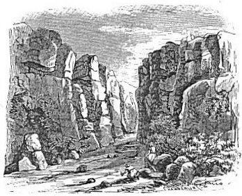
The mountains on the west vary in height from 2000 to 3000 feet above the water, and they rise less precipitously than those on the east. The latter are from 500 to 1000 feet higher. On both sides there is a narrow beach in most places, but on neither is it sufficient to allow a continuous passage between the hills and the water. No traveler has succeeded in passing entirely along the eastern coast, and along the western a part of the passage lies high up the bluff on an elevated shelf. The scenery along both shores is imposing on account of the solemn grandeur of the mountains and their sombre hues. In a few places, as at Ain Jid'y (En'gedi) on the west, and at the mouth of Wady Mo'jib (the river Arnon), on the east, the perpendicular walls of rock
|
| MOUTH OF THE ARNON. |
are full of grandeur. The latter spot is thus described by Lynch: "The stream, now 82 feet wide and 4 feet deep, runs through a [40] chasm 97 feet wide, formed by high, perpendicular cliffs of red, brown, and yellow sandstone on the southern side, and on the north a soft, rich red, all worn by the winter rains into the most fantastic forms, not unlike Egyptian architecture. It was difficult to realize that some were not the work of art. The chasm runs up in a direct line for 150 yards, and then turns with a slow and graceful curve to the southeast."30 On all sides, wherever there is fresh water there is luxuriant vegetation; but this occurs only where streams make their way into the sea. On the southeastern shore there is sufficient moisture to produce a very rank growth over a considerable space; elsewhere the strips of verdure are narrow and insignificant. There are two oases on the western shore, one called Ain Feskah, but a few miles from the northern end, and the other called Ain Jid'y, the ancient En'gedi, or
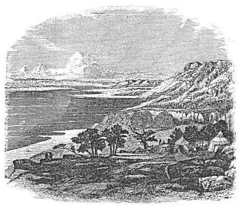 |
| SOUTHERN END OF THE DEAD SEA FROM EN'GEDI. |
spring of the kid. The latter is one of the most interesting spots about the Dead Sea. It is imperfectly represented, together with the southern portion of the sea, in the above cut. [41]
The name "Dead Sea" is post-biblical, and the earliest writer known to have used it is Pausan'ias, who wrote in the latter half of the second century of our era. It doubtless originated partly from the exaggerated stories in regard to the sluggishness of its waters and the deadly nature of its atmosphere, and partly from its supposed intimate connection with the fate of Sodom and Gomorrah. The tradition of its connection with this great catastrophe is traceable also in the name Bahr Lût (Sea of Lot), by which it is known among the Arabs. The earliest suggestion of such a connection that has come down to us, and the only one within the period of Bible history, is found in the apocryphal book of Esdras, where it is called the "Sodomitish sea."31 It is also called the "Sea of Sodom" in the Talmud. But its usual name in the Bible is "the salt sea," though it is sometimes called "the sea of the plain."32 The name "salt sea" was derived undoubtedly from its extreme saltness, and the name "sea of the plain" from its position at the southern extremity of the broad plain of the Jordan. The name "Dead Sea" has completely superseded all others in the language of modern literature, and will probably continue to hold its pre-eminence, notwithstanding the superstition in which it partly originated.
§ IX.
BEYOND THE JORDAN.
The country lying east of the Jordan is the last district to be included in our general description of Palestine. So much of it as belongs to the Jordan Valley has already been described in Section VII., and we now speak only of that which lies east of that valley. It is everywhere an elevated region, and its mountains are much more uniform in elevation than the hills west of the Jordan. The mountain-wall by which it breaks down into the Jordan Valley has a descent into that valley of from 3000 to 4000 feet, and an elevation above the sea-level of from 2000 to 3000 feet. The top of this wall, except where it rises into ridges or rounded knobs above its usual height, marks the general elevation of the country lying east of it; but after extending eastward about twenty miles, this elevated district is terminated by the still more elevated plateau of the great Arabian desert. Its southern boundary is the river Arnon, which flows from the vicinity of the desert westward [42] into the Dead Sea, through a chasm which it has cut for itself, and which is in some places 2000 feet deep. Its northern boundary is marked by the hills of the southern foot of Mount Hermon. This district is naturally divided into two by the river Yar'mûk, which runs chiefly on the parallel of the southern end of the Lake of Galilee. All south of this river is an undulating table-land, except where it is broken by a few rocky knolls and ravines. The name Gilead (hard, rocky region), by which it was known in the Old Testament period, suggests its general character. Its southern and northern extremities are now destitute of trees; but they have a rich soil, and they furnish fine grazing, besides abounding in fields of grain. It is only of late years that the Bed'awin inhabitants have become habituated to the cultivation of the soil; but they now cultivate many fields of grain which compare favorably with those found in the plains west of the Jordan. The central portion, especially that part immediately north of the river Jabbok, and in the vicinity of the western boundary, contains many groves of low-growing timber. The slopes and tops of the mountains are in many places covered with a thick growth of oaks and other forest-trees, among which the honeysuckle and other flowering vines are seen, while the open glades are decked with flowers in great abundance and variety. The river Jabbok (Wady Zerka) rises on the eastern side of this district, a half-mile above the ruins of Ammân' (the ancient Rabbath Ammon), and after flowing northward for some miles, turns to the west and cuts its way through to the Jordan Valley. It divides the district into two unequal parts, the greater part toward the south, and it is the only river of any importance in this region, except the two already mentioned. It is a perennial stream of considerable size, and abounds in fish even as high up as the ruins of Ammân'. This district is thickly dotted with the ruins of ancient towns and cities, many of which are extensive and magnificent, showing that it was once inhabited by a numerous population possessed of wealth and intelligence. At present it contains no town of importance, except Es Salt (the ancient Ramoth-gilead), which is said to have a population of 12,000. The remainder of the population, except that of a few small villages in the hills north of the Jabbok, consists of Bed'awin Ar'abs of the Ad'wân tribe. Their present chiefs, Goblân' and Fellâh', have acquired a world-wide notoriety by escorting nearly all the travelers and explorers who have visited their territory within the last thirty years. A Turkish garrison is kept at Es Salt for the purpose of holding in subjection the Bed'awin tribes, which were formerly very lawless. The district is called by the Ar'abs the Belkâ', and they boast greatly of its fertility. [43]
The district north of the Yar'mûk was anciently called Ba'shan (soft and level soil), and is, as this name indicates, a comparatively flat and very fertile region. It extends from the northern limit of Gilead to Mount Hermon.33 When this district was first conquered by Moses, it included within its limits Argob, the kingdom of Og, who is called "King of Ba'shan." It is probable that Argob was the territory of his tribe, and that he held the remainder of Ba'shan as conquered territory. It then contained sixty cities, "fenced with high walls, gates, and bars, besides unwalled towns a great many."34 In the days of Solomon it is again spoken of as containing the same number of cities, defended in the same way.35 It was celebrated for its fine groves of oak, and the oaks of Ba'shan are placed beside the cedars of Lebanon in the majestic imagery of the prophets.36 David gives prominence also, to the bulls of Ba'shan, saying,--
| "Many bulls have compassed me;
Strong bulls of Bashan have beset me round."37 |
In the New Testament period, as we see by the writings of Josephus, Ba'shan was divided into four districts. The most western, that bordering on the Lake of Galilee and the upper Jordan Valley, was called Gauloni'tis, and it is yet known under the same name in the corrupted Arabic form of Jaulân'. It lies nearly 3000 feet above the surface of the Lake of Galilee, and although it is now but little cultivated, it has exuberant soil. It is said that no less than 127 ruined villages are scattered over its surface.
Immediately east of the northern portion of Gauloni'tis was the district called Trachoni'tis, now called the Lejâh'. It is about 22 miles long from north to south, of a regular, almost oval shape, and 14 miles wide in the widest part. Its surface is covered with basaltic rock, black and hard, which appears, according to Mr. Porter, the best authority on this region, "to have issued from the innumerable pores in the earth in a liquid state, and to have flowed out on every side." He thinks that before cooling "its surface was violently agitated, and that it was afterwards shattered and rent by internal convulsions."38 Notwithstanding this, the region, he says, is thickly studded with deserted cities and villages, in all of which the houses are solidly built and of remote antiquity.39 This is the region called Argob in the Old Testament,--the term meaning the stony,--and [44]
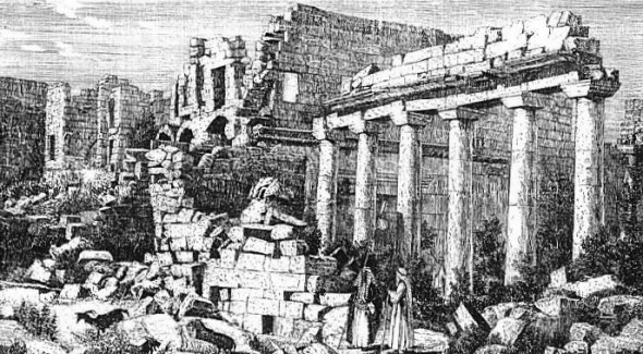 |
| STONE HOUSE IN THE LEJÂH'. |
| Page 44. |
Trachoni'tis is its Greek equivalent. It was inhabited during the period of the Roman dominion in Palestine by a people who lived chiefly by pillaging the surrounding districts, and who were full of rebellion towards the government.40 Such has been its history ever since.
South of Trachoni'tis and east of the southern portion of Gauloni'tis is the district called Au'ranitis by the Greeks and Haurân', a corruption of the Greek name, by the Arabs. The term Haurân' is also used by Ezekiel in a geographical passage which leaves us in doubt whether he applies it to this district or some other.41 Its surface is flat and its soil very rich. It contains more than one hundred towns and villages, most of which are deserted but not in ruins. Many of the buildings are remarkably strong, the walls being of great thickness and the roofs and doors being of stone.
Batane'a is a small, mountainous region east of the Lejah' and the Haurân', and its name is derived from the name Ba'shan. It abounds with forests of oak, possesses a rich soil, and is studded with towns of great antiquity, deserted, but in a remarkable state of preservation. See, on these districts, Smith's Dictionary, articles Ba'shan, Argob, Trachoni'tis, Haurân'; and Porter's "Damascus."
[LOB 19-45]
|
[Table of Contents] [Previous] [Next] |
J. W. McGarvey Lands of the Bible (1881) |
|
Back to BibleStudyGuide.org. These files are public domain. This electronic edition was downloaded from the Restoration Movement Texts. |